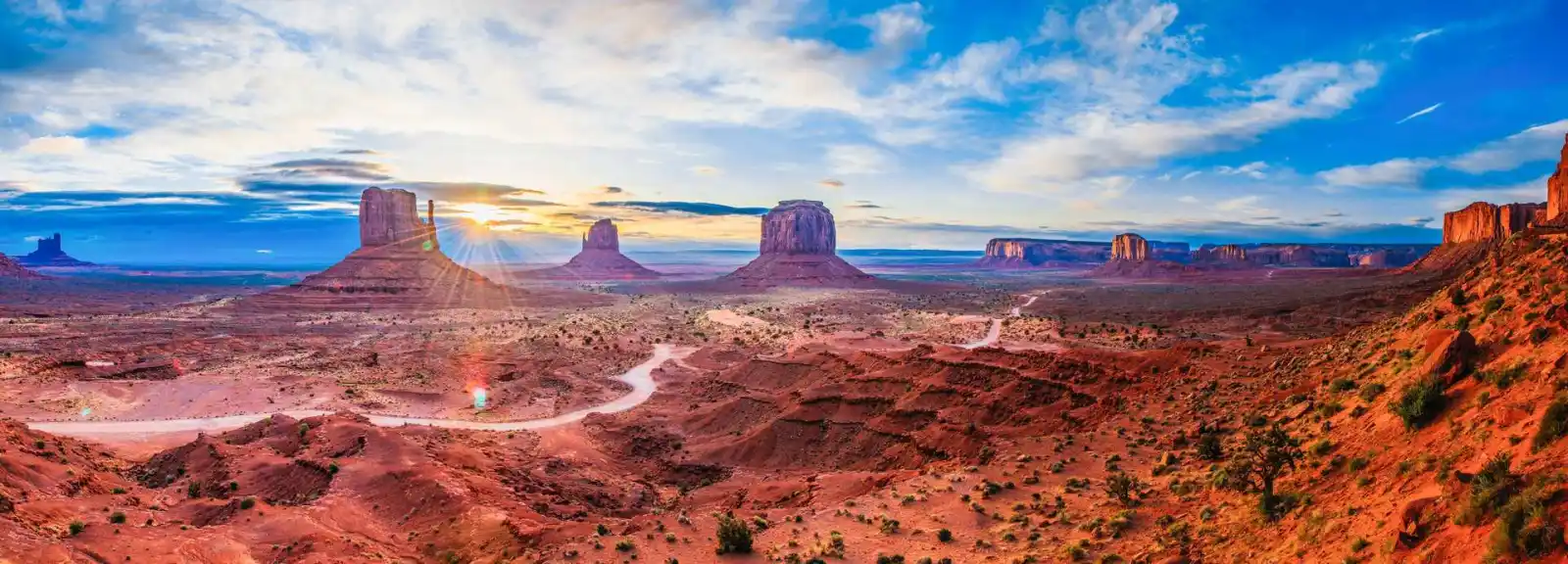
Merrick Butte & The Mittens in Monument Valley
Plan where to see Monument Valley’s most famous skyline from the Visitor Center, scenic drive, and Wildcat Trail area, with sunrise and photography tips.

Where to See Merrick Butte and The Mittens
Merrick Butte stands beside the East and West Mitten Buttes to form Monument Valley's most famous skyline. The easiest views are from the Visitor Center terrace, the scenic drive pullouts, and the Wildcat Trail area near West Mitten Butte, with sunrise and late afternoon offering the strongest light and contrast.
Visitors can appreciate the classic panorama without a guide, but Navajo-led tours provide closer access and more cultural context. For a broader explanation of the landscape and its Navajo setting, see About Monument Valley.
Quick Facts
-
Location
Monument Valley Navajo Tribal Park (UT/AZ border) -
Formation Age
~250–300 million years -
Best Time
Sunrise & sunset for photography -
Access
Visitor Center viewpoints; guided tours for close access -
Trail
Wildcat Trail near West Mitten (limited access)

Plan Your Visit

Monument Valley Navajo Tribal Park generally opens from sunrise to sunset. Hours change seasonally — check the Visitor Center for up-to-date information and entry fees.

Located along US-163, the valley is roughly 25 minutes from Kayenta, AZ and 25 minutes from Mexican Hat, UT. Park at the Monument Valley Visitor Center and meet tour operators at the designated booths.
Coordinates: 36.998, -110.098
Park Entry: Monument Valley Navajo Tribal Park
Accessibility: Viewpoints accessible; guided access for closer areas
Many visitors continue along the scenic drive route to John Ford’s Point, one of the most famous viewpoints overlooking the Mittens.

- Wear sturdy shoes and bring water — desert conditions can be harsh.
- The scenic loop is unpaved; a high-clearance vehicle is recommended.
- Respect Navajo cultural sites — do not climb or disturb rock art.
- Book guided tours in advance for restricted-area access and cultural interpretation.
History of The Mittens & Merrick Butte
The Mittens and Merrick Butte formed from ancient rock layers gradually eroded over millions of years. Long a landmark for the region’s Ancestral Puebloans and later the Diné (Navajo), these formations also entered global consciousness after appearing in classic Western films. Local guides share both geological and cultural narratives that reveal the valley’s deep human history.
History of Monument Valley
Frequently Asked Questions
Can I hike to the base of the Mittens?
The Wildcat Trail circles West Mitten Butte and is open to hikers. Other close approaches often require a Navajo guide—check tour options for guided access.